
For the trail 01 (= plateau 1) a proposal has been made by the Mountaineering Association of the Lasithi Plateau for it to be marked and recognized, but unfortunately the proposal is still pending.
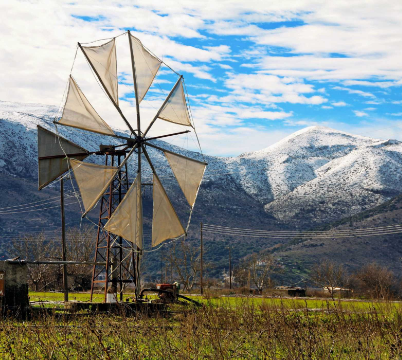
The trail starts from the village of Lagou, heads NW, passes through the place “Tou Katsouli o Lakkos” and reaches “Asfendami”. At this place, there used to be one of the largest mill sites in Crete. Today we can see the ruins of 23 windmills. This mill site was moved further west to Seli Ampelou after the Revolution of 1866-69.
A little lower than ‘Asfentami’, we can distinguish Vitsilovrysi, a spring that seems to have supplied water to the nearby settlement of ‘Karfi’, and next to it, a small sanctuary was excavated. The church seen further west is Saint George of Asfentami, for which a previous mention was made.
From ‘Asfentami’, we can follow two routes: one towards Papoura and the other towards Karfi.
Route to Papoura: We head southwest and reach a plateau at the top of the hill, where, according to archaeological findings, there was an ancient settlement that extended almost to the Selia of Ampelou.
“A small settlement in the Minoan period was inhabited by the people of the nearby Late Minoan settlement of Karfi, when they peacefully abandoned their inhospitable peak around the 10th century BC. Papoura then developed into a populous city in the following three or four centuries. The name of this city is not known to us. Various suggestions have been made in this regard: Lasynthos (Paul Faure), Datalá (Watrouss), etc.
“Papoura was abandoned during the Classical period. Apart from some test excavations and surface surveys, the site essentially remains unexplored.
“Route to Karfi: Very close to us, to the northwest, rises a massive rock that resembles a nail driven into the western slope of Selena. Between this rock and the nearby hill of Mikri Koprana, an important Sub-Minoan settlement has been excavated, which was named Karfi after the shape of the nearby rock.
“At the site of this settlement, during the Middle Minoan period (2200-1550 BC), there was a Summit Sanctuary. The first inhabitants settled here around the 12th century BC, and this settlement served as a large and wealthy mountain refuge (altitude 1250m) for the Minoans. It is estimated that at its peak, it had approximately 3,500 inhabitants.
“However, relatively soon, around the 10th century BC, the settlement was peacefully abandoned, and its inhabitants moved to the nearby Papoura. But even from here, the inhabitants soon relocated to the plains, where various settlements began to emerge on the northern slopes of the Plateau, such as in Donanti, Kefali, Kolla, etc.
“We return to the starting point of the mountain route (for those who attempted it) and head towards the last village of the right route, which will be the first if we choose the left one, namely the Limnaki Plateau.
